Basic Hydrology
Infiltration
Learning Objectives:
- Define infiltration in the context of hydrology.
- Understand the significance of infiltration in the hydrological cycle.
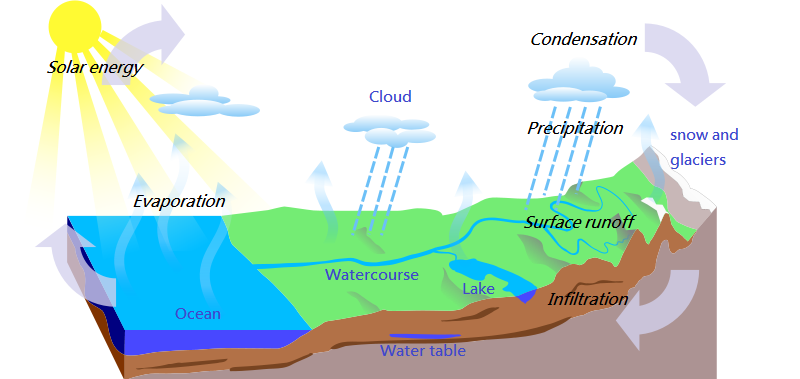
Infiltration refers to the process of water penetrating the soil surface. It plays a crucial role in the hydrological cycle and impacts groundwater recharge, runoff, and stormwater management.
Factors Affecting Infiltration- Soil Type: Texture, structure, and compaction influence infiltration.
- Antecedent Moisture Conditions: Previous soil moisture content impacts current infiltration rates.
- Slope: Steeper slopes often lead to faster runoff and reduced infiltration.
- Vegetation: Vegetation can enhance infiltration by breaking the impact of rainfall.
Rainfall
Learning Objectives:
- Define rainfall and its significance in hydrology.
- Describe common instruments and methods for measuring rainfall, including rain gauges and radar.
- Discuss the potential effects of climate change on rainfall patterns and intensity.
- Analyze the implications for infrastructure and water resource management.
- Convective rainfall: A packet of air which is warmer than the surrounding air due to localized heating rises upward and consequently undergoes cooling, condensation and precipitation.
- Orographic rainfall: The moist air masses get lifted up to higher altitudes due to the presence of the mountain barriers and consequently undergo cooling, condensation and precipitation.
- Frontal or Cyclone rainfall: When two air masses meet, they do not mix readily due to differences in temperature and density. A front is an imaginary line separting two contrasting air masses.
- The rainfall is collected and measured in a rain gauge, sometimes also referred as pluviometer, ombrometer and hyetometer.
- Rain gauge must be installed in such a way that:
- The ground must be level and in the open and the instrument must present a horizontal catch surface.
- The gauge must be set as near the ground as possible to reduce wind effects but it must be sufficiently high to prevent flooding, etc.
- The instrument must be surrounded by an open fenced area of at least 5.5m X 5.5m.
- No objects must be nearer to the instrument than 30 m or twice the height of the obstruction.
- Non-Recording gauges: Symon's Gauge
- Recording Gauges
- Tipping bucket type
- Weighing bucket type
- Natural Siphon type
- Latitude
- Temperature
- Moisture
- Air Masses
- Frontal Activity
- Differential Heating
- Mountain Barriers
- Distribution of Land and Water


.jpg)
Storm Hyetograph:
It depicts the temporal distribution of rainfall intensity during a storm event. This graph is essential for assessing stormwater runoff and designing drainage systems. Engineers use it to analyze the rainfall pattern, determining peak intensities and durations. Understanding storm hyetographs helps ensure infrastructure can handle rain-induced loads and prevents flooding.

CambridgeBayWeather, Public domain, via Wikimedia Commons
Solved Example: 9083-01
Which one of the following points should be kept in mind while selecting the site for a rain gauge station?
A. The site where a rain gauge is set up should be close to a meteorological observatory.
B. The rain gauge should be on the top of a hill.
C. A fence, if erected to protect the rain gauge from cattle etc. should be located within twice the height of the fence.
D. The distance between the rain gauge and the nearest object should be at least twice the height of the object.
Correct Answer: D
Solved Example: 9083-02
Rainfall with an intensity of 6 mm/h is classified as:
A. Trace rain
B. Moderate rain
C. Heavy rain
D. Light rain
Correct Answer: B
Solved Example: 9083-03
The Rainfall Intensity of Light Rain is:
A. Upto 2.5 mm/Hr
B. Upto 3.0 mm/Hr
C. Upto 5.00 mm/Hr
D. Upto 7.5 mm/Hr
Correct Answer: A
Solved Example: 9083-04
The maximum average depth due to one day storm over an area of 100 km$^2$ is 100 mm. Depth-Area-Duration (DAD) curves indicate that for the same area of 100 km$^2$ the maximum average depth for a 3 hour storm will be:
A. 100 mm
B. More than 100 mm
C. Less than 100 mm
D. None of these are correct
Correct Answer: C
Solved Example: 9083-05
Which of the following is a non-recording rain gauge?
A. Weighing type rain gauge
B. Tipping Bucket rain gauge
C. Simon's rain gauge
D. Float type rain gauges
Correct Answer: C
Solved Example: 9083-06
The theissen weights of 4 rain gauges A, B, C and D covering a river basin are 0.15, 0.25, 0.30 and 0.30 respectively. If the average depth of rainfall for the basin is 5 cm and rainfall recorded at B, C and D are 5 cm, 4 cm and 5 cm respectively, what is the rainfall at A?
A. 5 cm
B. 6 cm
C. 7 cm
D. 8 cm
Correct Answer: C
Solved Example: 9083-07
Imaginary lines joining equal ___________ is known as isohyets.
A. Height
B. Humidity
C. Rainfall
D. Pressure
Correct Answer: C
Solved Example: 9083-08
What is the diameter of funnel which collects rain water in tipping bucket rain gauge?
A. 100 mm
B. 200 mm
C. 300 mm
D. 400 mm
Correct Answer: C
Solved Example: 9083-09
The method used for estimating missing rainfall is:
A. Normal ratio method
B. Station year method
C. Plotting position method
D. Rational method
Correct Answer: A
Solved Example: 9083-10
When rain falls as water droplets of size less than 0.5 mm, so light in weight to appear as floating in air, is termed as:
A. Drizzle
B. Snow
C. Dew
D. Rain
Correct Answer: A
Runoff
Learning Objectives:
- Define runoff in hydrology and its importance in the hydrological cycle.
- Explain the role of runoff in surface water availability and management.
Runoff refers to the movement of water over the land surface and into bodies of water. It plays a critical role in the hydrological cycle, influencing water availability and flood management.
Runoff Generation Mechanisms:- Surface Runoff: Water flows over the ground surface due to excess precipitation or impermeable surfaces.
- Subsurface Runoff: Water infiltrates the soil and then moves laterally to emerge as runoff.
- Base Flow: Slow, steady discharge from groundwater into streams and rivers.
Hydrograph:
Hydrograph refers to a graphical representation of the flow rate of water in a river or stream over a specific period of time. Hydrographs are essential tools for hydrological analysis, providing insights into the response of a watershed to precipitation events. They depict the temporal distribution of runoff, showcasing how rainfall is transformed into streamflow. Engineers use hydrographs to assess peak flows, flood durations, and overall watershed behavior. Understanding hydrographs is crucial for designing hydraulic structures, managing water resources, and mitigating the impact of floods. Key elements of a hydrograph include the rising limb (reflecting the increasing flow during a storm), the peak flow, and the recession limb (indicating the gradual decrease in flow post-storm).Solved Example: 9901-01
The rainfall figures for successive 30-minute intervals are 35, 40, 120, 85, 45, 45 and 30 mm/hr. If the $\phi$-index is 35 mm/hour, determine W-index.
A. 24.3 mm/hour
B. 44.3 mm/hour
C. 34.3 mm/hour
D. 54.3 mm/hour
\begin{align*} P &= (36 + 40 + 120 + 85 + 45 + 45) \times \dfrac{30}{60}\\ &= 200.5\ \mathrm{mm} \end{align*} \[t_r = 3.5 \ \mathrm{hr}\] \begin{align*} \mathrm{W-index} &= \dfrac{P - R}{t_r}\\ &= \dfrac{200.5 - 80.5}{3.5}\\ &= 34.28\ \mathrm{mm/hr} \end{align*}
Correct Answer: C
Solved Example: 9901-02
The observed annual runoff from a basin of area 500 $km^2$ is 150 $Mm^3$ and the corresponding annual rainfall over the basin during the same year is 750 mm. What is the runoff coefficient?
A. 0.2
B. 0.67
C. 0.4
D. 0.5
Correct Answer: C
Solved Example: 9901-03
A storm with 150 mm precipitation produces a direct runoff of 8.7 cm, with incremental hourly rainfall values being 0.6, 1.35, 2.25, 3.45, 2.7, 2.4 1.5 and 0.75 cm/hr. Estimate the $\phi$-index of the storm.
A. 0.925 cm/hr
B. 0.825 cm/hr
C. 0.625 cm/hr
D. 0.725 cm/hr
Correct Answer: B
Solved Example: 9901-04
A catchment consists of 40% area with run-off coefficient 0.30 with the remaining 60% area with run-off coefficient 0.50. The equivalent run-off coefficient will be:
A. 0.38
B. 0.42
C. 0.48
D. 0.52
Correct Answer: B
Solved Example: 9901-05
Which of the following statements is/are correct?
- Isochrones are curves of equal pore water pressure
- Isochrones depict the variation of the pore water pressure along with the depth of the soil sample
- Isochrones vary with time
A. 1 only
B. 2 and 3 only
C. 1 and 2 only
D. 1, 2 and 3
Correct Answer: B
Solved Example: 9901-06
A canal is 80 km long and has an average surface width of 15 m. If the evaporation measured in a class A pan is 0.5 cm/day, the volume of water evaporated in a month of 30 days is (in m$^3$)
A. 12600
B. 18000
C. 180000
D. 126000
Correct Answer: D
Solved Example: 9901-07
The run off increases with:
A. Increase in intensity of rain
B. Increase in infiltration capacity
C. Increase in permeability of soil
D. All of the above
Correct Answer: A
Solved Example: 9901-08
A direct runoff hydrograph due to a storm idealized into a triangular shape has a peak flow rate of 60 m$^3$/s occurring at 25 hours from its start. If the base width of this hydrograph is 72 hours, and the catchment area is 777.6 km$^2$, the runoff from the storm is:
A. 1 cm
B. 2 cm
C. 5 cm
D. 10 cm
Correct Answer: A
Solved Example: 9901-09
The streams that do not receive any base flow contribution are termed as:
A. Intermittent streams
B. Ephemeral streams
C. Perennial streams
D. None of the above
Correct Answer: B
Solved Example: 9901-10
The term base flow denotes:
A. Delayed groundwater flow reaching a stream
B. Delayed groundwater and snowmelt reaching a stream
C. Delayed groundwater and interflow
D. The annual minimum flow in a stream
Correct Answer: A
Watersheds
Learning Objectives:
- Define a watershed (drainage basin or catchment) in hydrology.
- Explain the importance of watershed characteristics, including size, shape, slope, land use, and soil type.
- Identify key topographic features that define watershed boundaries.
- Understand the principles of watershed management, including land use planning, erosion control, and the implementation of Best Management Practices (BMPs) to protect water quality and prevent flooding.
A watershed, also known as a drainage basin or catchment, is an area of land where all water drains to a common outlet, such as a river, lake, or ocean.
- Effective watershed management is critical for protecting water quality, reducing flood risk, and conserving natural resources.
- It involves land use planning, erosion control, and the development of Best Management Practices (BMPs).
- Watershed analysis is essential for assessing flood risk and determining areas prone to flooding.
- Understanding the interaction between rainfall, runoff, and topography is key to flood risk assessment.
Rational Formula:

SilentSword22, CC BY-SA 4.0, via Wikimedia Commons
Solved Example: 9084-01
Watershed is a:
A. Drainage basin contributing the runoff to a single outlet
B. Hydrological entity
C. Unit of area extent in which hydrologic cycle completes
D. All are correct
Correct Answer: D